L-3 Avionics WX500 Stormscope Detection System
 |
|||
| Part Number: | WX500 |
||
- Overview
- Specifications
- Features and Benefits
- Display Options
- Stormscope Video
The Calm BEFORE the Storm
Stormscope Weather Mapping Systems were the first airborne instruments developed specifically to detect and map thunderstorms by analyzing the radiated signals of electrical discharges from storm cells. During the cumulus stage of a thunderstorm, storm cells are usually precipitation-free, and weather radar is unable to show activity. Stormscope, by detecting the electrical activity already present as the storm builds, provides an accurate view of areas that should be avoided. Stormscope processes both azimuth and range to determine the location and intensity of dangerous thunderstorm cells – then presents the findings in real-time.
Stormscope Series Key Features
- Plots lightning as it happens, before the onset of precipitation
- Displays lightning in 25, 50, 100 and 200 nmi ranges
- Pilot selectable Cell and Strike modes
- 360-degree view or 120-degree forward looking
- Updates lightning information every second
- Strike Rate indicator details building or dissipating storms
- Integrates with SkyWatch Collision Avoidance Systems
Designed to interface with most MFD’s, the WX-500 allows pilots to view lightning information directly on their MFD - on a dedicated page or overlaid on the map.
- Up to 200 nm range
- Pilot selectable strike and cell modes
- Display of airspace in 120° forward and 360° surrounding views
- Heading stabilized when configured with compatible system
- Stores lightning data on all ranges simultaneously
- Strike rate indicator
- View lightning on multiple displays at the same time
- View on dedicated page or overlaid on moving map
System Specifications
WX-500 Stormscope FEATURES & BENEFITS:
> Up to 200 nm range
> Pilot selectable strike and cell modes
> Display of airspace in 120° forward and 360° surrounding views
> Heading stabilized when configured with compatible heading system
> Stores lightning data on all ranges simultaneously
> Strike rate indicator
> View lightning on multiple displays at the same time
> View on dedicated page or overlaid on moving map
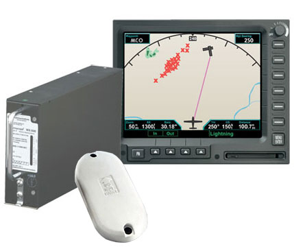
STORMSCOPE® MODEL WX-500
Displaying lightning information at ranges of 25-200 nm, the Stormscope WX-500 is designed to interface with the most popular, new generation of multi-function displays. With the WX-500, you can view lightning information directly on your MFD — either on a dedicated page or overlaid on the moving map. Even if your MFD already has datalink weather, nothing provides the accuracy and timeliness of a Stormscope system for mapping ALL lightning activity.
The WX-500 lets you choose between strike and cell mode, depending on your preference. By adding the Stormscope WX-500 to SkyWatch® or SkyWatch® HP systems, traffic and lightning information can be superimposed over datalink weather or radar returns (display dependent). The operating modes of Stormscope WX-500 and SkyWatch are controlled directly through your MFD or radar indicator (with RGC350), eliminating the space and cost of an extra controller.
Whether you are a commercial pilot flying an all glass cockpit or a General Aviation pilot with a traditional panel, Stormscope fits the model that suits your needs. Whether viewing on a dedicated display or overlaying the information on a moving map, Stormscope offers the most display options of any weather provider. With its multiple output options, Stormscope keeps pilots informed of lightning strikes the second they happen. Stormscope is certified and flying with almost every display manufacturer. The list is growing everyday, so please call your L-3 Avionics Systems representative at 1-800-253-9525 to find out if your display will support Stormscope.
WX-500 Display Options
- Garmin G1000, G900, GNS400/500 Series, GMX-200
- Chelton Flight Systems FlightLogic Synthetic Vision EFIS
- Sandel ST3400, 3500, 4500
- Aspen Avionics Evolution Series
- Bendix King KMD850/550
- Avidyne FlightMax, Entegra, EX500/600, EX5000, MHD300, Alliant
- Select Radar Indicators (most Radar Indicators using the RGC-350)
- Apollo MX-20, UPSAT MX-20, Goodrich i-linc
- OP Technologies
- Moving Map MFD