
Garmin GTN 625 GPS
 |
|||
| Part Number: | 010-00811-50 |
||
Premier Avionics is a
Garmin GTN750, GTN650 and G600/G500 Demo Dealer
- Overview
- Features
- Specifications
- In the Box
- Accessories
- Comparison
- Image
- GTN Video
GTN 625 is a 2.64" standalone GPS navigator that puts high-resolution terrain mapping, graphical flight planning, multiple weather options and traffic display right at your fingertips.
Touch & Go
With its revolutionary touchscreen interface, GTN 625 puts primary functions just a few taps away. Pan across the map screen by swiping your finger across the 4.9" high-resolution TFT display, and enter waypoint data with the onscreen alphanumeric entry. Raised grips in the bezel and a shelf across the lower edge of the display serve as gripping points in both smooth and turbulent flight conditions. Traditional concentric knobs are also available for data input. If you have a GNS 430W/530W, active flight plans automatically crossfill from the GTN to the GNS, or just manually crossfill user waypoints between devices.
Navigate with Ease
Edit your entire route using the map screen and enter new waypoints or modify existing ones. A handy "rubber band" feature lets you grab any leg of your flight plan route or direct-to and move it to accommodate a deviation or ATC amendment to your flight plan. Enter your most recently visited or nearest airports as waypoints and “Direct To” destinations.
Execute Precision Approaches
The robust 15-channel GPS receiver generates 5 position updates per second. This SBAS/WAAS-certified technology allows you to fly GPS-guided LPV glidepath instrument approaches down to as low as 200 ft. In addition, precise course deviation and roll steering outputs can be coupled to select autopilots so that IFR flight procedures may be flown automatically. This includes all ARINC 424 leg types, except RF legs. (For example, when coupled with a G500/G600 flight display, the aircraft can fly fully coupled missed approaches, including heading legs.)
See More Than Ever Before
GTN 625 brings enhanced situational awareness to your cockpit. With high-resolution terrain mapping — including topography features, cities, airports, terminal areas and SUAs — and optional Class B TAWS alerting, you’ll find your way around the airspace safely and with ease. Smart Airspace™ automatically highlights airspace close to your current altitude and de-emphasizes airspace away from the current altitude. The system even allows you to load and follow Victor and jet airways. On the ground, built-in SafeTaxi® airport diagrams give you geo-referenced runways, taxiways, FBOs and hangars available in either the U.S., Europe or Canada.
Add Traffic, Weather & More
The dual-link GDL® 88 allows the GTN 625 to display up to 60 ADS-B traffic targets. TargetTrend™ relative motion technology offers a faster way to judge the direction and closure rate of intruding targets in relation to their aircraft’s position. And unique SURF technology supports the display of ADS-B-equipped surface targets on SafeTaxi airport diagrams, including taxiing aircraft and ground vehicles. GDL 88 can also receive the FAA’s subscription-free FIS-B weather broadcasts that include graphical NEXRAD radar information, as well as NOTAMs, METARs and TAFs. GTN gives GDL 88 the WAAS position source required for ADS-B, so a WAAS version of the GDL 88 is not required. Consider adding a Traffic System to compliment GDL 88 for the best possible traffic coverage from now until 2020.
Couple the system with a GDL® 69 series datalink receiver to receive XM MX Satellite Weather and SiriusXM Satellite Radio (subscriptions required). An optional GSR 56 provides World Wide Weather data virtually anywhere on the globe, as well as the ability to make and receive phone calls and send and receive texts messages while in the air.
And because the GTN 625 can control the GTX™ 33 remote transponder, installing it could also save you valuable panel space.
Stay Up to Date
The GTN 625 features a front-loading SD™ card reader, so you can easily update your databases. PilotPak™ database bundles are now available on a single aircraft basis, saving you money and simplifying the update process. Visit flyGarmin.com to learn more.
GTN 625 is now available for purchase from your Garmin Authorized Dealer. See it in action at an upcoming seminar or in person at a demo dealer location, or with our free PC Trainer download or iPad app.
*Most updated features are expected to be available via free software release in the fourth quarter 2012.
![]()
![]()
- menu-driven graphical interface on color LCD touchscreen display
- feature-rich MFD capabilities: moving map, airways, approaches and more
- GPS TSO’d to C146c, authorized for Class 1,2,3 (LPV)
- GPS WAAS-certified to Gamma-3 approach capability
- WAAS-corrected GPS signal accuracy to 1 M RMS
- graphical flight planning (including airway navigation)
- extensive optional interface capabilities: lightning, weather, traffic, TAWS-B terrain alerting
- integrated control/display for remote transponder
- flight control system interface for select autopilots
- optional XM WX satellite weather and SiriusXM Satellite Radio
- SafeTaxi® airport diagrams
- award-winning product support and 2-year warranty
What's in the Box:
- GTN 625
- Cleaning cloth
- SD card with databases
- Installation kit
- Simulation software DVD
- Familiarization video DVD
- Pilot's guide
- Cockpit reference guide
- Complimentary database update certificate
Package contents may vary per version. See Premier Avionics for more information.
 |
Garmin PC Trainer 010-00478-00 $25.00 |
 |
Garmin GTN Familiariztion Video/DVD 010-00479-00 $25.00 |
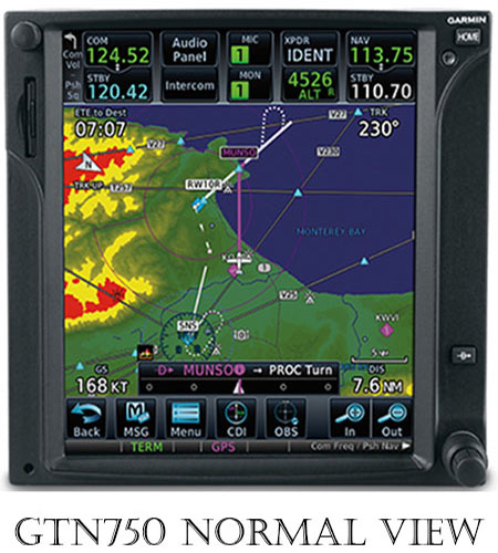
GTN750 Product Images
 |
||||||
Hover over any picture below to see a larger image above. |
||||||
 |
 |
 |
 |
 |
 |
 |