
Avidyne EX600 Multi-Funtion Display
 |
EX600 MFD |
||
- Overview
- Functionality
- Panning
- Features
- Upgrade an EX500
- CMax
- Specifications
- EX600 Video
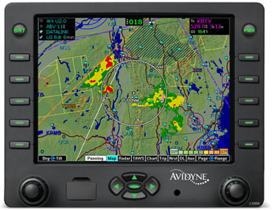
EX600 Multi-Function Display
Avidyne’s EX600 delivers easy-to-use, datalink-ready multifunction display capability for general aviation airplanes & helicopters.
The Avidyne Advantage
Avidyne is committed to improving situational awareness and safety for general aviation pilots by focusing on developing products that are easier to use. Now, with our new EX600 Multi-Function Display (MFD), Avidyne offers the most feature-rich, pilot-friendly and easiest-to-use multifunction display available.
The EX600’s user interface dramatically improves your ability to access and display
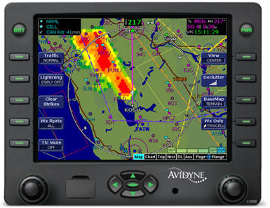
critical flight data. This design philosophy keeps operation simple and consistent by allowing you to select and display what you need on a single easy-to interpret integrated moving map. As a radar display replacement, the EX600 provides easy access to radar modes, tilt control, and bearing adjust.
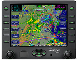
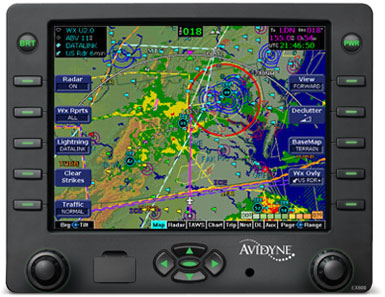
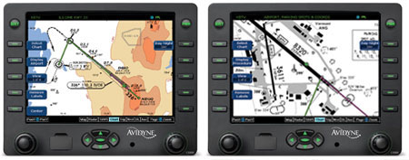
With the EX600’s “map-centric” operation and our new Map Panning feature, you can display a moving map of your flight plan and view datalink weather all along your route of flight. And view on-board Wx Radar. And special-use airspace. And traffic. And terrain. And color lightning. All without ever leaving the map page. It’s the only MFD available that provides the complete picture. And it’s the easiest to use.
EX600 Multi-Function Display
The Best MFD Available
The EX600 keeps you connected with the complete weather picture, allowing you to view datalink graphical weather information that is seamlessly integrated with your flight plan moving map, lightning, traffic, and terrain display.
Bigger, Brighter Display
The EX600 features an all-new, high-resolution, sunlightreadable LED-backlit color liquid-crystal display that provides the brightest, most versatile big-screen display available. With over 40% more pixels than our previous-generation MFD, and an incredibly wide viewing angle, the EX600 provides the look and feel of big-screen MFDs.
CMax™ Electronic Approach Charts
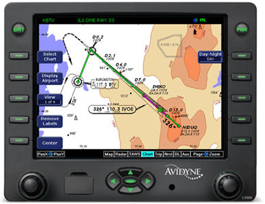
All EX600s include CMax™, providing a world-wide library of geo-referenced approach charts and airport diagrams that help you manage and access critical flight information and reduce the amount of paper required on board your aircraft.
Utilizing Jeppesen’s trusted JeppView™ Electronic Airway Manual, CMax makes accessing an approach or viewing an airport diagram a breeze. At startup, your departure airport chart is automatically loaded for ease of orientation, especially at unfamiliar fields. Your destination airport diagram and the list of available approaches are automatically loaded at the time your flight plan is entered. Charts can also be loaded for nearby airports along your route from the Trip Page using the EX600’s Auto-Fill™.
Radar, Datalink Weather & More
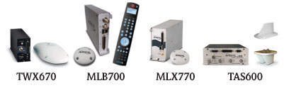
Weather is a critical factor in the successful completion of any flight and Avidyne leads the industry in weather avoidance-capable multifunction displays. In addition to interfacing with 19 different on-board weather radar systems, the EX600 also displays color lightning and both broadcast and two-way satellite datalink weather.
Interfaced with MLB700 or XMD076/A, the EX600 can display cell height and cell movement including speed and forecasted direction.
Broadcast Satellite Datalink Weather for CONUS
The EX600 displays Broadcast Datalink weather giving pilots comprehensive, graphical information about weather conditions all across the Continental United States (CONUS). The EX600 displays NEXRAD radar mosaic, Hail Warnings, AIRMETs, SIGMETs, graphical and textual METARs, TAFs, Temperatures and Winds Aloft, TFRs, and datalinked Lightning.
World-Wide Two-Way Satellite Datalink Weather
Internationally, the MLX770 Satellite Datalink Transceiver delivers worldwide satellite-based datalink weather and two-way text messaging for EX600 owners flying anywhere in the world. International weather products include worldwide METARs, TAFs, SAT IR, Lightning, and regionalized NEXRAD radar imagery.
CMax Airport Diagrams
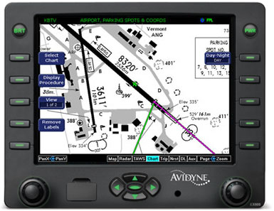
CMax airport diagrams include 6,004 worldwide locations, 5,695 of which are geo- referenced charts, meaning the EX600 MFD can overlay the flight plan and aircraft ownship symbol, making it possible to view the aircraft position directly on runways, taxiways, and ramps. Panning keys allow details of the chart to be shown.
Informative Trip Page
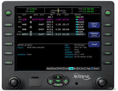
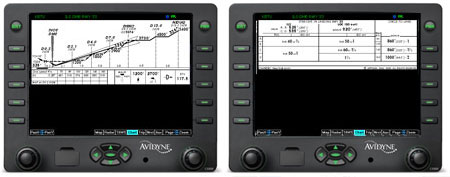
From the Trip Page, you have easy access to vital information, including graphical METARs for all reporting airports and one-button access to CMax approach charts for any airport along your route. Decoded METARs, Textual TAFs, and Winds and Temperatures Aloft can also be viewed at the push of a button.
Unique NRST to Destination Page
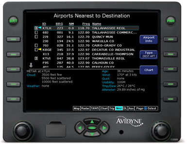
In addition to “Nearest to Present Position,” the EX600 also provides Avidyne’s unique “Nearest to Destination” Page which shows graphical and decoded METARs at the destination and surrounding airports, making it easy to monitor weather ahead and to select an alternate when needed.
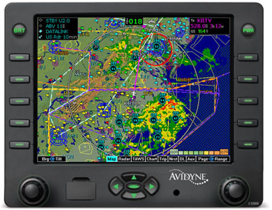
Map Panning & QuickPan™
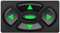
With the EX600, Avidyne has added an easy-to-use panning function that allows you to scroll to virtually any point on the map to view weather, airspace, and other points of interest.
Dedicated panning keys make it easy to view any area on the map, especially helpful for viewing weather at your destination. The four directional keys provide precise control, and the center key enables Avidyne’s exclusive QuickPan feature, which toggles the display between the panned position and your present position. While panning, the map can be zoomed in or out so you can easily see the close-in details or see the whole picture.
Panning along your route of flight, you can see exactly how the weather is looking, allowing you to make strategic decisions that can easily save you time and fuel.
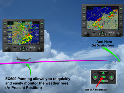
In addition to a larger display area, the EX600’s exclusive QuickPan feature allows the pilot to quickly toggle between the present position and a panned-to position with a single button push.
Two-Way Text Messaging
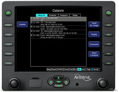
When interfaced with the MLX770, you not only get worldwide weather, but you also have the ability to send and receive text messages or emails while flying, allowing you to communicate with someone on the ground via an e-mail connection or compatible SMS-capable mobile telephone.
Wx Radar over Map
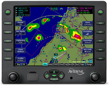
In addition to a dedicated radar page like other MFDs offer, the EX600 is the only MFD that can overlay your on-board Wx Radar right on your base map, along with Flight Plan, Terrain, Traffic, SUAs and datalinked weather data such as graphical METARs, SIGMETs, and AIRMETs.
Color Tactical Lightning
The EX600 can also interface with the Avidyne TWX670 to display real-time color lightning overlaid right on the moving map. On-board lightning provides a tactical complement to the strategic benefits of satellite-based datalink weather, and the addition of color provides more meaningful display of critical weather data.
Replaces Your Old Radar Indicator
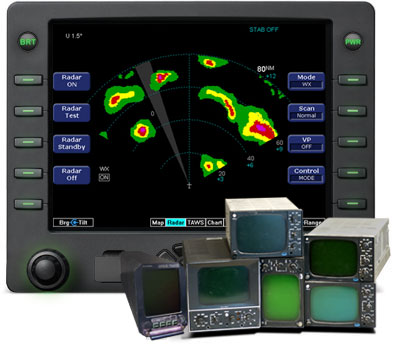
The EX600 is designed to replace existing CRT-based radar indicators for any of 19 different radar systems. Dedicated Range, Bearing and Tilt controls and exclusive features like BeamView™ and TiltView™ make it much easier to use than competing radar-capable displays.
Enhances Helicopter Mission Capability
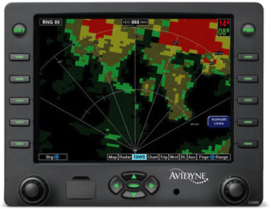
Helicopter operators will appreciate the versatility of the EX600’s detailed moving maps and the ability to display Traffic, TAWS, Charts, and Datalink Weather. (EGPWS/TAWS shown)
World-Wide Datalink Weather

International customers will appreciate the EX600’s ability to display worldwide satellite-based datalink weather and two-way text messaging when coupled with the Avidyne MLX770 Satellite Datalink Transceiver. (European Sat IR shown)
Easy to Update. Easy to upgrade.
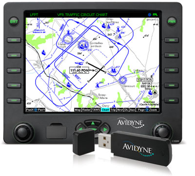
NAV and Chart databases are easily updated through the USB port right on the front bezel. (European VFR charts shown) For existing EX500 customers, the EX600 is a pin-for-pin replacement that provides a larger display and adds our unique Map Panning capability.
Upgrade your existing EX500 to EX600
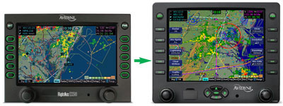
EX500 owners now have the option to upgrade to the new EX600.
Why Upgrade to EX600?
- Larger (5.8-inch diagonal) Transflective Display
- Better readability in sunlight & in low light
- Full 640x480 VGA Display
- 40% More Pixels
- 25% larger viewing area
- New Bezel and Glass
- Dedicated directional Map Panning Keys
- Makes it easy to move to anywhere on the map
- Especially useful for viewing the weather at your destination
- Exclusive QuickPan™ function
- Easily toggles between panned-to position and present position
- Ideal for monitoring weather at destination throughout your flight
- Upgrade and trade-in programs available
The biggest safety and utility enhancement of the EX600 is its new QuickPan function which makes it easy to view weather at your present position and at your destination with a single button push.
Avidyne’s FlySafe discounts make upgrading to the EX600 a great time to consider additional safety sensors including Datalink Weather, Color Lighting and Traffic Advisory Systems.
While all electrical wiring is identical, the EX600 is a little more than half an inch taller than the EX500 and thus will require some minimal panel work and changing of the mounting tray in order to accommodate the upgrade.
![]() Click here to learn more about the EX500 to EX600 upgrade program.
Click here to learn more about the EX500 to EX600 upgrade program.
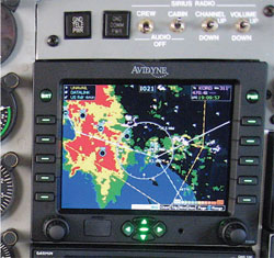
EX600 CMax™
"I was glad to have Jeppesen charts on the Avidyne display to show me exactly where I was on the airport." - J. Mac McClellan - FLYING Sept. 2006 and Avidyne's website 2013
CMax™ Approach Charts allow EX600, EX500 and EX5000 customers to view approach charts and airport diagrams along with their aircraft’s position and flight plan for improved situational awareness during the most critical phases of flight.
Cmax is now standard on all new EX600, EX500 and EX5000 Multi-Function Displays.
CMax™ Approach Charts, Avidyne’s innovative implementation of this electronic chart capability, displays approach charts and airport diagrams with an overlay of the pilot’s flight plan and present position. CMax provides on-demand access to the worldwide library of JeppView electronic charts and airport diagrams and dramatically improves the pilot's ability to manage cumbersome paper charts.
At startup, the departure airport chart is automatically displayed for ease of orientation, which is especially valuable when taxiing at unfamiliar fields.
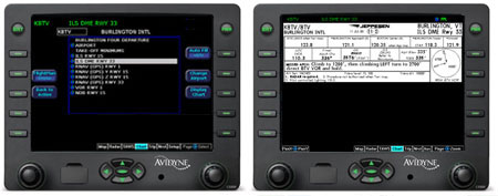
The destination airport's list of available approaches is automatically loaded at the time your flight plan is entered, and can be viewed easily using the Auto-fill capability, and the pilot can easily select and view any approach chart for any airport in the database.
CMax™ automatically switches to the destination airport diagram when ground speed drops below 40kts.
CMax™ uses Jeppesen’s JeppView Electronic Airway Manual chart service to reduce the amount of paper required on the flight decks of Avidyne-equipped aircraft. In addition, CMax makes managing and accessing flight critical information more efficient, while eliminating the need for pilots to file traditional revision updates in their Airway Manuals. Jeppesen will send Avidyne customers periodic CD-ROM updates which are loaded onto a personal computer to display and print charts while on the ground, and transferred through the FlightMax dataloader for updates in the airplane.
Charts Updates are available through Jeppesen at: www.jeppesen.com.
CMax improves safety and it’s easy to use. Easily load approach charts for your destination using the “auto fill” button, or easily browse and select charts for any airport in the database. CMax shows aircraft position and flight plan right on the approach chart making it much easier to visualize your location throughout the approach. Critical obstacles and terrain are displayed for added safety. As the aircraft ground speed drops below 40kts, CMax automatically switches the display from the approach procedure chart to the airport diagram.
CMax improves surface navigation. CMax airport diagrams include 6,004 airports, 5,695 of which are geo-referenced (we can show aircraft position during taxi). 1,998 are U.S. locations.CMax’s detailed airport diagrams show runways and taxi ways, which is especially useful when operating on unfamiliar airports. CMax™ eliminates the need for “progressive taxi instructions,” and makes it easier to find a particular FBO or parking area.
CMax improves incursion awareness. CMax shows “Runway Incursion Hotspots.” These are areas on certain airports designated by the FAA where ground control may have limited visibility or where there is high traffic flow or other known history of incursion activity.
CMax improves chart management. CMax makes managing and accessing flight critical information more efficient, while eliminating the need to file traditional revision updates in Airway Manuals. Jeppesen sends Avidyne customers periodic CD-ROM updates which are loaded onto a personal computer to display and print charts while on the ground, and transferred through the FlightMax dataloader for updates in the airplane.
EX600 Specifications
Applicable TSO
| TSO C63c | Airborne Weather Radar |
| TSO C110a | Airborne Passive Thunderstorm Detection |
| TSO C113 | Airborne Multipurpose Electronic Display |
| TSO C118 | Traffic Alert & Collision Avoidance (TCAS) |
| TSO C147 | Traffic Advisory System (TAS) |
| TSO C157 | Flight Information System - Broadcast (FIS-B) |
| TSO-C43c | Temperature Instruments |
| TSO-C106 | Air Data Computer |
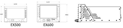
LCD Viewable Size
• 640x480 pixels (full VGA)
• Diagonal: 5.7” (145mm)
• Width: 4.61” (117mm)
• Height: 3.48” (88mm)
EX600 size (no tray)
• Width: 6.24” (158mm)
• Height: 4.93” (125mm)(front), 4.21” (107mm)(rear)
• Depth: 10.99” (279mm)
Weight
• 4.75 lbs (2.15 kg)
• Fixed wing Tray - 0.9 lbs (0.41 kg)
• Helicopter Tray - 4.1 lbs (1.86 kg)
Power Requirements
• Max 3.0A @ 28VDC
Environmental
• DO 160E
• To 50,000 ft.
• -20C to +55C Operating
• +70C Short Term C
Cooling
• Internal forced air cooling provided
Warranty
• 2 Years parts & labor included
• FlexCare™ Extended warranty service available
Datalink Interface
• Avidyne MLB700 Broadcast Datalink Receiver
– Using WSI InFlight® Aviation Weather & SIRIUS® Satellite Radio
• Heads Up Technologies XMD-076/A
– Using Baron Services weather & XM® Satellite Radio
• Avidyne MLX770 Two-Way Datalink Transceiver
– Using Avidyne/WSI Services Weather & Text Messaging
Vector-Graphic Moving Map
• Americas Jeppesen NavData®
• International Jeppesen NavData – Optional
GPS/FMS Interface
• Garmin GTN 650/750 Series
• ARINC 429 GAMA Graphics
• RS-232
Heading Interface
• ARINC 407 – Synchro XYZ
• ARINC 429
Electronic Approach Charts
• CMax™ – Jeppesen Electronic Airway Manual Charts
• European VFR Charts
• Airport Diagrams
Lightning Interface
• Avidyne TWX670 Tactical Lightning Detection
• L3 WX-500 Stormscope® Weather Sensor
Traffic Interface
• Arinc 735 & RS-232
• Avidyne TAS600/TAS610/TAS620 TAS
• Ryan 9900B/9900BX TAS
• Honeywell KTA870/KMH880 TAS/IHAS
• L3 Skywatch 497 /Skywatch HP TAS
• Garmin GTX330 TIS Transponder
• L3 791 TCAS I
• Honeywell CAS66A TCAS I
Terrain Awareness
• Color-Contoured Terrain Base Map Built in
– Americas Terrain & US Obstacle Data
– International Terrain Data – Optional
EGPWS/TAWS Interface – Optional (Class B)
• Honeywell MK V, VI, VII, VIII
• Honeywell KMH880 IHAS
• Honeywell KGP560/KPG860
Radar Interface – Optional
• Collins WXR250/270/300
• Bendix RDR130/150/160
• Bendix RDR1100/1200/1300
• Bendix RDS81/82/82VP/84/84VP/86/86VP
• Bendix/King RDR2000/2100